Muir Woods National Monument is located in Marin County in Mill Valley, California. With over 6 miles of maintained trails, a day hiking in Muir Woods is a great way to escape the busy city life and find peace in nature. Some of the best hiking trails in Muir Woods are accessible and kid-friendly, making for a great family day. Reservations are required for parking, so you will have to plan a bit. But setting aside some time to explore the beauty of these redwoods on a Muir Woods trail is highly recommended.
Table of Contents
WHAT TO KNOW BEFORE YOU GO TO MUIR WOODS NATIONAL MONUMENT


MUIR WOODS HOURS OF OPERATION
Depending on the season, the park opens at 8 am and closes at 5 or 6 pm. The café and gift shop are open 9 am-4 pm. The visitor center opens at 8 am and closes about 30 minutes before the park. You can check current hours and closures here.

RESERVATIONS ARE REQUIRED TO PARK
Advanced reservations are required to park at Muir Woods National Monument. Check this link for the reservation page. For $9.00/vehicle, you choose a 30-minute arrival window for parking, and you are welcome to stay as long as you would like. You can also opt to pay your $15/person entrance fees during this reservation process. Muir Woods is part of the National Park system, so do not pay the fee in advance if you use one of the National Park Annual Passes to enter Muir Woods.
THERE IS NO CELL SERVICE
There is no cell service approaching the Muir Woods National Monument entrance. This is important to consider when planning a day in Muir Woods. Your parking reservation needs to be downloaded or printed in advance to show the attendant. You will not be able to pull up your email to show the attendant. Also, if you are taking rideshare to get there, such as Uber or Lyft, you will need a plan for leaving. You will not be able to request your ride home with no cell service.
MUIR WOODS SHUTTLE
A shuttle runs from Mill Valley and Sausalito to board and take to the park. Unfortunately, we did not use the shuttles, but you can find current information about the shuttles here.


PLAN FOR WEATHER
Muir Woods is located in Marin County, known for having cooler, foggy/cloudy days. Due to the canopy of the redwood forest, the sun can barely peek through the trees, making shade abundant. This naturally brings the temperature down, so I highly recommend layers for everyone in the family during a Muir Woods hike. When temperatures are high, the forest remains cooler with the shade. After heavy rains, the forest can be incredibly muddy, so plan accordingly with little kids!


DINING OPTIONS
There is no eating allowed in the forest area of Muir Woods National Monument. We had packed a delicious picnic packed and realized quickly we would not be enjoying it during our hike. There are many benches outside the entrance for picnicking, which we did. We had picked up the delicious Sweet Affair bakery in Walnut Creek and I wasn’t about to pass up my favorite sandwich (turkey on butter crust) and cookie (peanut butter chocolate chip) combo!
If you plan a longer hike that heads into Mount Tamalpais State Park, you will be able to picnic in the state park. In addition, there are no garbage cans anywhere along the trail. Therefore, if you snack or have a beverage, make sure to pack out ALL of what you bring in.


MUIR WOODS TRADING COMPANY CAFE
Muir Woods has a small cafe and gift shop right at the entrance. The Muir Woods Trading Company Cafe serves a variety of lunchtime-style sandwiches and salads. Check out the menu here. You can also pick up a coffee or pastry if visiting early or in chilly weather.
HIKING TRAIL ETIQUETTE
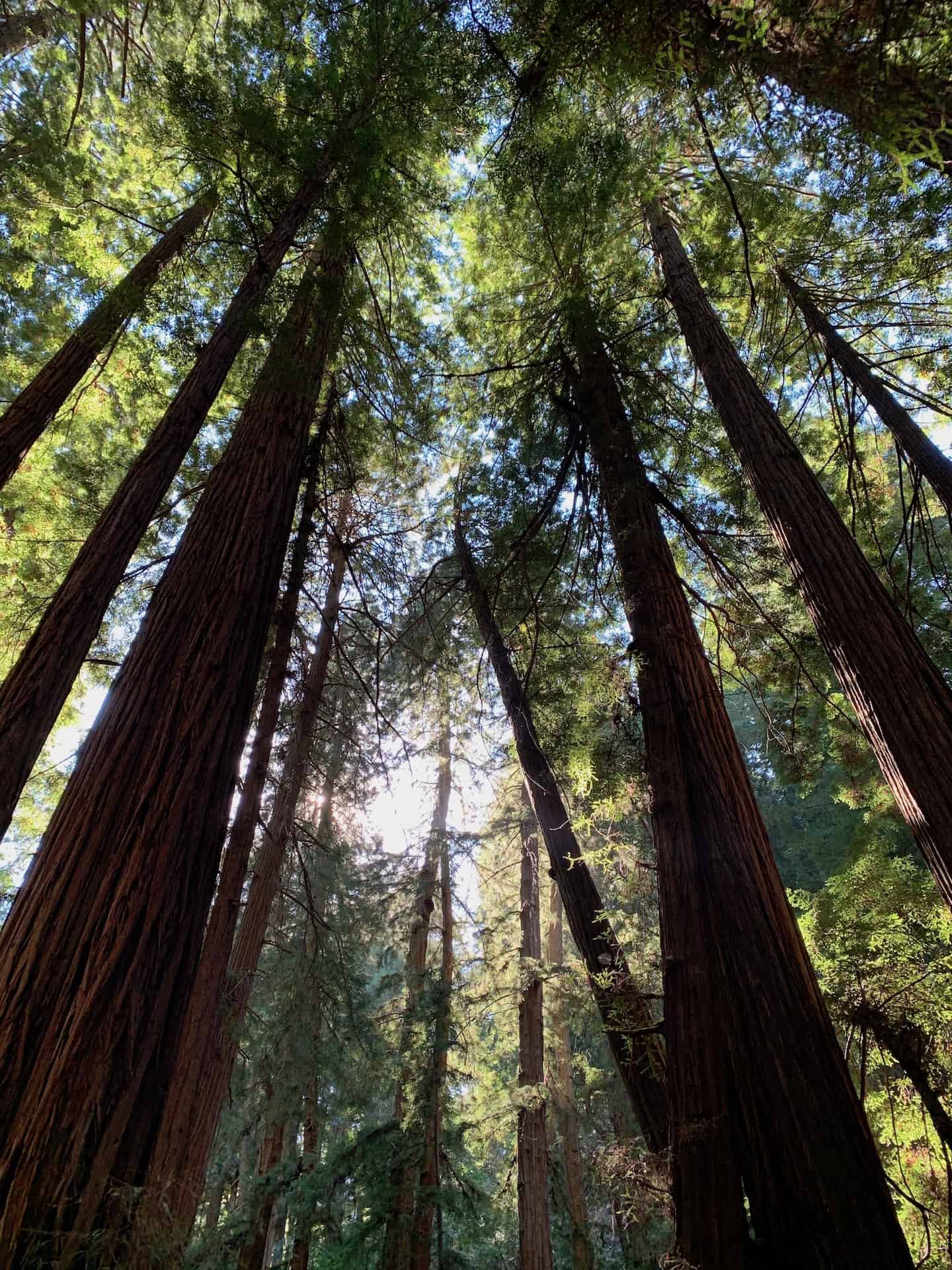
When you visit Muir Woods, it is important to respect the beauty of the forest. Redwood trees are some of the tallest trees in the world and have very fragile and shallow roots. Therefore, it is essential to stay on the hiking trails in Muir Woods to protect this beautiful place. The trails are well maintained and marked, so you will not be confused. It pains me to see people blatantly ignoring signs and hopping over fences to get their perfect Instagram picture. The fragile state of the forest is also why there are no bikes or pets allowed in Muir Woods. In addition, be aware of poison oak warnings all over the forest, especially with littles. Please make sure to respect the forest so it will be here for future generations.


THE JUNIOR RANGER PROGRAM
As you know from my blog, I love the Junior Ranger programs at National Parks. This program was great because it was much shorter than the large National Parks, and my son could complete the activities during our visit. In addition, I love the info in the books and how we all learn about the park more as he works through his activities. You can download the activities ahead of time or pick up a book in the visitor center or when you pay your entrance fee ($15/adult when we were there in 2020 and 2022).


THE REDWOOD CREEK TRAIL – THE MAIN MUIR WOODS HIKE


The Redwood Creek Trail is the main trail through the redwood forest. This is where you will start a day in Muir Woods, and you can add to the adventure from this trail. The trail is a wooden boardwalk that is well maintained and wheelchair accessible. The trail follows the creek and has four bridges that cross over each side. Since we visited during COVID, the trails were designated one-way, so we could not travel back and forth, although that option would have allowed more back-and-forth to see everything. The bridges offer you three different options for looping through the forest. Bridge one is right by the cafe at the entrance. Once you start up the creek into Muir Woods, you have several options for expanding your hike.
LOOP TO BRIDGE TWO
The first option for your Muir Woods hike is to only walk up to bridge two, a 1/2 mile, 30-minute loop through the start of the forest. This loop gives you an exquisite taste of the forest and is an excellent option for those not looking to walk too much. There is very little elevation gain on this trail. This loop starts at the Muir Woods visitor center and takes you through Founder’s Grove and the Pinchot Tree.
This tree is one of the largest in the grove and is dedicated to Gifford Pinchot in 1910, the first chief of the U.S. Forest Service. Pinchot lobbied President Roosevelt to save these redwoods. This first loop offers beautiful views of the creek and towering coastal redwoods above. The beginning of the Canopy View Trail is to the right of this loop.


LOOP TO BRIDGE THREE
The loop to bridge 3 is pretty short and will turn your walk into a 1 mile, 1-hour tour of the grove. You can enjoy the giant redwoods of the Bohemian Grove trail on this portion of the walk. As you approach bridge 3, you can either cross the bridge to loop back towards the Visitor’s Center or continue for more adventure.


LOOP TO BRIDGE FOUR
If you continue to bridge four, you will create a two-mile loop through the redwood forest that is well worth it. This portion of the main Redwood Creek Trail takes you through Cathedral Grove, a beautiful, quiet part of the trail. As I mentioned earlier, the wooden boardwalk and trails are very well-maintained. They are even adding a portion of the trail in this area.
CATHEDRAL GROVE
I read somewhere that you should enter this area with purpose and reflect on your intention as you walk through. Signs ask for quiet in the grove, and it is beautiful. We entered the grove focused on gratitude as we were with my parents whom we rarely get to adventure with. Practicing gratitude for a moment, no matter your circumstances outside of your visit is empowering in nature. So take a moment of pause to reflect in the grove during your day in Muir Woods.
A quote from John Muir was ringing in my head as we walked through this particular area in the grove. Due to the beauty and quiet, my son enjoyed working on a few pieces of his Junior Ranger book on this portion of our hike. We all enjoyed taking in the sounds of the forest.
Several longer trails leave from this loop – the Fern Creek Trail, Camp Eastwood Trail, and Bootjack Trail. Hikers can combine the Fern Creek and Eastwood trails into a less than 4-mile loop through the forest, wildflowers, and Mount Tamalpais State Park. Fern Creek Trail can be combined with the Mt. Tam Lost Creek Trail and back to the Canopy View Trail in Founder’s Grove for a two-hour, quieter trek through the forest. The Bootjack Trail will take you on a beautiful 7-mile loop into Mount Tam State Park as well.
In every walk with nature, one receives far more than one seeks.
– John Muir


HIKING THE HILLSIDE TRAIL


Once you reach bridge 4, you can U-turn and head back through Cathedral Grove to bridge three or cross over to begin the Hillside Trail to loop around. This route gives you a 2-mile, 1 1/2 hour trek through the forest. I highly recommend going this way as it gives you a different perspective on the beauty you have seen. In addition, it gives you a new view of the forest since you were walking on the forest floor before this trail. Suddenly you are on a hillside, looking down at the paths where you were before. It is essential to be careful with young kids on this trail, as some drops are steep, and there are no guard rails. This trail begins with a large hill up from the bridge but then levels out. It is a great option that will take you back to bridge two.


You will be back on Redwood Creek Trail when you come off the Hillside Trail at bridge 2. The walk back to the entrance and Visitor Center is very short and shaded. I highly recommend adding the Hillside Trail to your Redwood Creek loop. Please note the Hillside Trail is not stroller friendly.


DON’T MISS THESE GEMS NEAR MUIR WOODS
After hiking through Muir Woods, chances are you will be seeking more adventure or a relaxing meal. Here are some of our favorite places to stop by after our Muir Woods adventure.
THE PELICAN INN & MUIR BEACH
A few minutes down the road from the Muir Woods National Monument is Muir Beach, where you also find the relaxing and quaint Pelican Inn. This inn takes you back to 16th century England is a great place to come and enjoy a beverage or meal after your Muir Woods hike. This small inn is home to a great pub that delivers sustainable and delicious English fare.


We visited on a gloomy day, and the dining room’s fireplace and cozy feel were a perfect stop on our Marin County adventure. We had the fish and chips as well as the roasted carrots. Both were great, and I cannot wait to return for an overnight stay to enjoy the Beef Wellington with a glass of wine by the fire.


On a sunny day, I can imagine these lawns are a great place to picnic, as people were gathered doing just that even in wet weather. The patio was green and inviting. Don’t forget to step out to see Muir Beach after your meal. This quiet cove is a favorite for sunbathing and bonfires by locals and is accessed by the 450-foot bridge that connects Muir Beach to the parking lot.


MUIR BEACH OVERLOOK
Muir Beach Overlook is a beautiful place to end your day. Follow the staircase out from the parking lot for panoramic views of the Pacific Ocean, Muir Beach, and the Point Reyes Peninsula on a clear day. History buffs will enjoy seeing the remnants of observation bunkers used by the San Francisco Coastal Defense System in WW2.


If you are craving more adventure, follow the 1.5-mile coastal trail to Slide Ranch and down to the North Beach tidepools. This 3-mile round trip adventure is fun for kids and on our next time list!
NEXT TIME LIST
- Hike the 3.1 mile Fern Creek, Lost & Ocean View Loop
- Hike the 6.3 mile Bootjack Trail Loop
- Picnic and hike the 9.7 mile (difficult level) Ben Johnson Trail (aka Dipsea Trail) from Muir Woods to Stinson Beach
Anything you would add to a day in Muir Woods? If you are looking for another great hike in the Bay Area, check out my post about Oakland’s Huckleberry Botanic Regional Preserve Loop.


