Are you looking for a quick way to submerge yourself in nature from the East Bay? Living in Southern California, we were craving some of the lush greenery Northern California hiking offers after the holidays. The Huckleberry Botanic Regional Preserve Interpretive Loop Trail was a great way to escape the post-holiday business and enjoy a short afternoon hike. The loop takes you down into a beautiful forest and luscious change in scenery filled with bright green ferns and aromatic bay trees.
Table of Contents
VISITING OAKLAND’S HUCKLEBERRY BOTANIC REGIONAL PRESERVE
The Huckleberry Botanic Regional Preserve is tucked away in the Oakland hills, sandwiched between the East Bay and San Francisco. The preserve is run by the East Bay Regional Park District and is well maintained. At the start of the trail, you can pick up a park brochure that includes a trail map and information about the 21 interpretive panels along the 1.7-mile loop.
PARKING AT THE HUCKLEBERRY BOTANIC REGIONAL PRESERVE
Parking was easy, as there is a small lot at the park entrance on the left side of Skyline Blvd., just after the Sibley Volcanic Regional Preserve. The parking area has several picnic tables to enjoy, as well as bathrooms and trash/recycling cans. Unfortunately, there are no dogs or bikes allowed on the Huckleberry Loop.


HIKING THE HUCKLEBERRY BOTANIC REGIONAL PRESERVE
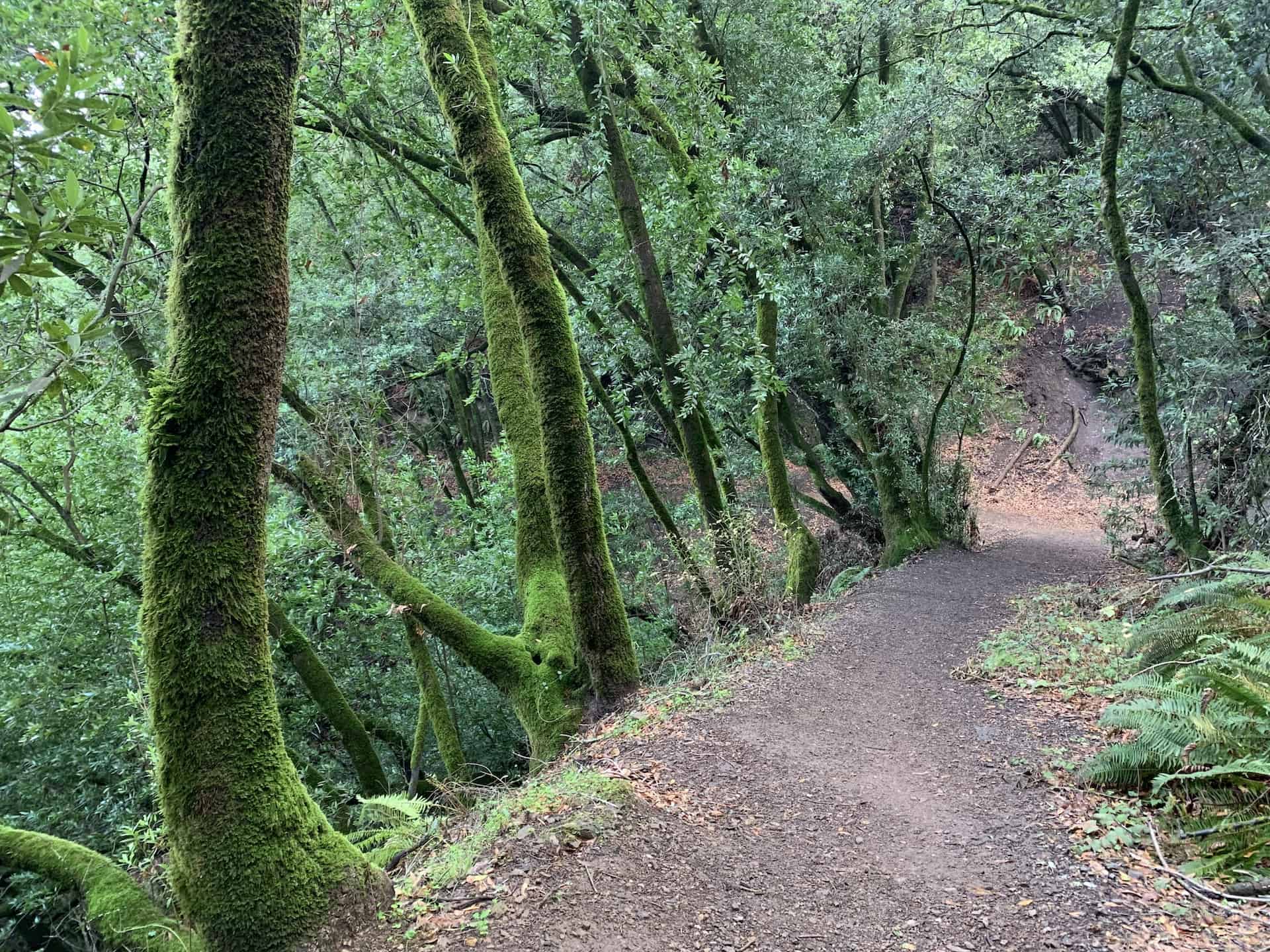
The Huckleberry Botanic Regional Preserve Interpretive Trail loop is 1.7 miles and took us less than 1.5 hours. The loop takes you down into a beautiful green fern and bay forest and teaches you about the local flora and fauna along the way. The unique climate of this area has created a moist environment that is home to many native plants that cannot be found anywhere else in the Bay Area. We loved the change of scenery and damp feel under the canopy of greens.


STARTING YOUR HIKE
At the start of the loop, you can either take the Lower Huckleberry Loop Trail to the left or the Upper Huckleberry Loop Trail to the right. The left takes you down a set of stairs into the fern and bay forest. We opted for this direction, knowing we would be climbing back up as we looped around. Many hikers opt to take the flatter Upper Huckleberry Loop Trail out a bit and back for a less strenuous hike. This is an excellent option for families with young kids concerned about distance. However, the Lower Huckleberry Loop Trail was the highlight of our hike. I highly recommend starting to the right, down the Lower Loop Trail.


LOWER HUCKLEBERRY LOOP TRAIL
We visited after light rains, so the trail was slightly muddy. The sun was peeking through the clouds, but the canopy of trees made for a primarily shady and damp hike. The trail can be slippery and steep at times. I can see this trail being very muddy after heavier rains, so plan your footwear appropriately. The smell of bay leaves filled the air throughout the hike, making for a peaceful feeling winding through the fern and bay forest on the lower half of the loop.


The greenery was plentiful, and the tree canopy made you feel like you were hours away from the busy Skyline Blvd and cities just outside of the preserve. The Lower Huckleberry Loop covers interpretive panels 21 to 16 as you move down the interpretive panel list when starting from the lower trail. Shortly into your hike, you reach another fork in the trail. Continue on the trail to the right, the Lower Huckleberry Loop Trail. The path to the left will take you to the 31-mile Skyline National Trail into Sibley Volcanic Regional Preserve (North) or Reinhart Redwood Regional Park (South).


UPPER HUCKLEBERRY LOOP TRAIL
After interpretive panel 16, you will see a sign heading up towards the Upper Huckleberry Loop Trail. As you begin to climb up, turn around for beautiful views of Mt. Diablo through the trees.


The climb up the “connector” portion of the Lower Trail to the Upper Trail is steep but short at .11 miles. There are several sections of stairs to help on muddy days.


After the climb, you will reach another sign and head right to continue on the Upper Huckleberry Loop Trail back towards the trailhead. Heading left will take you on the Upper Pinehurst Trail into Reinhardt Redwood Regional Park.


DETOURS
Shortly after connecting to the Upper Loop Trail, we took a slight detour to the right towards interpretive panels 14 & 15. After an uphill stretch through some bushes, we came out into a clearing with beautiful views of Mt. Diablo. There was also a bench where we enjoyed a snack and the sunshine. This would be an excellent place for a picnic or extended rest when hiking with our kids.


After our detour, we continued along on the Upper Huckleberry Loop. We immediately noticed it was a much flatter path along the ridge. We took another detour to see interpretive panels 9, 10 & 11. The clearing was much smaller than the previous clearing we discovered, so we quickly headed back to the main trail. As we continued along the main trail, we enjoyed seeing the red bark of the manzanitas as well as the sprawling bushes of the coast huckleberry.


MANZANITA TREES
At one point, a live manzanita tree has grown over the trail and gives you an up-close view of the beautiful bark. It is against the law to carve into the branches of these beautiful trees, as they are protected in this preserve. Although manzanitas are abundant on the upper loop in this preserve, they are eventually overtaken by the huckleberry or chinquapin native to the area.


As you approach the trailhead, you find yourself winding through similar greenery as the start of your hike. Finally, there are two benches where you can rest and take in the final views and smells of bay leaves surrounding you!


This trail was a beautiful getaway from the East Bay. We visited in December 2020, when COVID numbers were surging, and everyone on the trail was wearing a mask. The trial is thinner, but we could step aside when parties need to pass. I would love to explore the Sibley Volcanic Regional Preserve next door with more time. Some trails connect the two preserves.

LAST STOP – GRIZZLY PEAK
Don’t forget to stop at Grizzly Peak for incredible views (on a clear day) of the Bay Bridge, San Francisco skyline, and Golden Gate Bridge. Grizzly Peak is right on your way to Huckleberry Botanic Regional Preserve from the East Bay. As you head up towards the Preserve from the East Bay, you exit Fish Ranch Road right before the Caldecott Tunnel and then take a left onto Grizzly Peak Blvd. for a little over 2 miles before hitting Skyline Blvd. Although giant logs have blocked the main turnouts, the view is still exceptional from different points on the road.

We pulled on the side of the road as we left the preserve and crossed Grizzly Peak Blvd. to take in the view. This pullout was a great spot to take in city views at night in high school. However, I did read police are patrolling and citing between 9 pm-6 am. Apparently, the views were not only attracting people but also smoking, bonfires and fireworks. These do not pair with high fire danger, so “hanging out” is no longer allowed. But do stop to enjoy the view!

Do you love getting into nature from the East Bay? Check out my post on Muir Woods. What are some of your favorite hikes in the Bay Area? We are always looking for new things to explore!

